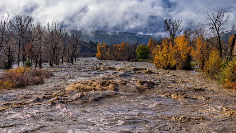
Pagosa Springs and surrounding communities grapple with new climate extremes. Two historic floods combined with two erratic wildfires in Archuleta County within a 14-month window leaves local leadership re-considering emergency response tactics and floodplain management. The San Juan River peaked at 15.02 feet on the morning of Oct. 23, edging out last year’s record of 12.82 feet in October 2025. It marked the highest crest on record in Pagosa Springs since a historic flood in 1911.
This story is sponsored by Durango Pizza and Sky Ute Casino Resort.
Our Sponsors

Learn More
Transcript
The rivers know no boundaries, right? We’re dealing with what we believe is a major catastrophic event.
You’re watching the Local News Network, brought to you by Durango Pizza and Sky Ute Casino Resort.
I think what occurred on Thursday with the peak on Friday morning has totally informed differently how we look at planning for the future, because I think these events are becoming more and more common, and certainly with two in the last two years and the increased fire potential. We certainly have a vulnerable population to natural disasters.
There’s a lot more destruction and debris, sediment deposit. We’re seeing a lot of road damage and sidewalk damage, trail damage throughout the community. There’s a lot of infrastructure that’s been compromised. Electric is down all over the community. And there’s been a lot more localized flooding in the area that has been a lot more catastrophic for residents.
We have a broad range of damage that occurred to residential infrastructure. So primarily the San Juan River, the Piedra River, the Rio Blanco, and we do have damage down on the Navajo River. We certainly now have isolated islands of community that have no way in and no way out. So everybody was affected in some way, shape or form. We do what we can with the, the resources that we have available to us locally. And as we were understanding what that damage was, we made the request for a team to come out of the Colorado National Guard. In addition to the guard’s air resources, the Division of Fire Prevention and Control provided an air asset for us. So what they’re doing at this point is assisting us with ground search and rescue operations, welfare checks, supply delivery to affected communities. And then the air search and rescue is assisting with evacuation. We still have a large backcountry recreational population in the forest. We are in the middle of second hunting season. We know that a number of hunters went into the back country prior to the event. We do have areas that are access compromised at this point, evaluating and reviewing how we’re going to get everybody out. So the next week, while we get through those missions, that’s what people are going to see. We’re going to see a lot more presence from first responders, particularly military first responders. After that, we’re transitioning into recovery and we’ve got to do initial damage assessments so that we can quantify that accurately to be able to be in a position to hopefully leverage some assistance from outside of the county.
Our flood recovery in 2026 that we did for the 2025 flood recovery was 90% done. We basically did a lot of embankment stabilization, sediment removal throughout the downtown river corridor, debris removal, rock structures were fixed throughout town. Most of them have held up pretty well, and I definitely think that we would’ve fared a lot worse if those were not in place for this year’s flooding. It’s a little disheartening to see all of that work get overshadowed by this flood event, and a lot of it will have to be redone all over again. The more areas that we can actually work with nature and try and create more floodplain management where it is more of a wetland, the better that we’re going to be in the long run. Obviously, there’s going to be roadways that are closed for a little while and areas that are going to be off limits to the community until we can get them stabilized so that they’re safe to drive on and the trails are safe to walk on. This kind of flooding is definitely an indicator that we need to be ready for these kind of events and plan accordingly.
For up-to-date information, visit Archuleta County Sheriff’s Office Facebook page. And for more stories like this, visit LNN.news.